

UPDATE: (Sept. 16): Crews are expecting limited fire activity, with showers and thunderstorms expected in the evening.
Dollar Fire: On Sunday, crews began rehabilitating the handline on the south side of the Dollar Fire. Fire suppression repair activities will occur in conjunction with guidance from Resource Advisors.
Snag Fire: Warm Lake Road is now open to the public, but the 409 extending south into the fire area from the Warm Lake Rd remains closed.
Near the Fish Hatchery and Warm Lake area, firefighters continue structure preparation efforts and are performing chipping operations along the 474 Road.
Structure preparation in the Horsethief area is complete.
Goat Fire: Crews have successfully begun a dozer line along the northwestern edge of the Goat Fire, starting near the gap between the Goat and the Snag, running about midway between the edge of the fire and the 409 Road. This work will continue as crews work to extend this dozer line further southwest.
UPDATE: (Sept. 14): West Mountain Fires near and around Cascade, Idaho have reached over 64,000 acres of burned area. The Snag, Dollar, and Goat fires have over 690 personnell working on controlling the blazes. The Goat Fire has no containment yet, while the Snag fire has the most contained, with 27%.
Dollar Fire:
The Dollar Fire doesn't have any staff on site right now, but repair work will be done with advice from Resource Advisors. Today, the focus will be on fixing hand lines. Fire Suppression Repair involves immediate actions taken after a fire to fix damage and reduce soil erosion caused by firefighting efforts.
Snag Fire: Yesterday, helicopters helped by using sling loads—nets carrying equipment—since the locations were hard to reach. Crews are patrolling the northwest side of the fire along Warm Lake Rd. To the northeast, firefighters have finished assessing structures in the Warm Lake area and are working on preparing them. In the southeast, firefighters will evaluate Rice Peak Lookout to see if it needs protection. On the west side, structure assessments and protection efforts are ongoing in the Horsethief area.
Today, crews will start building a dozer line from the west edge of the Snag Fire towards the Horsethief Reservoir and will scout for another dozer line further south on Horsethief Rd. Masticators will work alongside dozers to clear fuel from these lines.
Near the southern tip of the Snag Fire, off 409 Rd, crews are mopping up after recent pile burning to remove fuel.
Goat Fire: Crews are working to close the gap between the northern part of the Goat Fire and the southern part of the Snag Fire using dozer and handlines. On the northwest side, crews are improving and connecting various small UTV roads and trails to build indirect and direct lines along the northeastern edge of the fire. On the west side of the Goat Fire, firefighters are looking for ways to build a line connecting the 099 Trail to the 417 Road and then to the 409 Road. Firefighters are also widening the 409 Road to create a larger fuel break, which will support this effort.
UPDATE: (Sept. 14): West Mountain Fires have reached a combined burned area of, over 64,000. Currently the Snag Fire is the most contained with 25% and the least contained is the Goat Fire at 0%
The weather conditions could aid a factor in helping control some of the fire lines, yet thunderstorms due pose a greater threat on expanding the fire in certain zones.
Dollar Fire: The Dollar Fire has some interior burning but is not spreading much. As conditions permit, there will be efforts to repair damage from firefighting activities. Suppression repair focuses on fixing areas affected by fire control measures to prevent soil erosion and other impacts. This includes repairing fire lines, roads, trails, and other areas used during the firefighting process.
Snag Fire:Most of the remaining heat in the Snag Fire is on the north side.Crews are patrolling the western side and evaluating when they might add more containment. They are also starting to remove unneeded equipment. Near the southern tip of the fire, off 409 Rd, crews are monitoring pile burns done a few days ago to clear out fuel. On the east side, fire managers are finalizing plans for protecting the Fish Hatchery and Warm Lake areas.
Goat Fire: Firefighters are looking for ways to create a fire line connecting 417 Road to 409 Road to isolate the Snag and Goat Fires from the Horsethief area. They are building both direct and indirect lines to close the gap between the northern part of the Goat Fire and the southern end of the Snag Fire. They are also widening 409 Road to make it a larger fuel break. Plans are underway to build a dozer line from Horsethief Rd. toward the Snag Fire to block the Goat Fire's northward and westward spread. A structure protection team is preparing structures and plumbing at Horsethief Reservoir.
UPDATE: (Sept. 10, 10:30 a.m.): Monday’s fire behavior was less active than expected, and this was in part due to a change in wind direction that brought more smoke from the Lava Fire, settling over the valley and tampering fire behavior.
A Fire Weather Watch has been issued for Wednesday, Sept. 11 for expected thunderstorm activity. These storms could bring rain but also lightning. A cold front will start coming through the area beginning Wednesday, with more significant chance of moisture as the week progresses.
A community meeting will be held at 7 p.m. on Tuesday, Sept. 10 at the Cascade Fire Department.
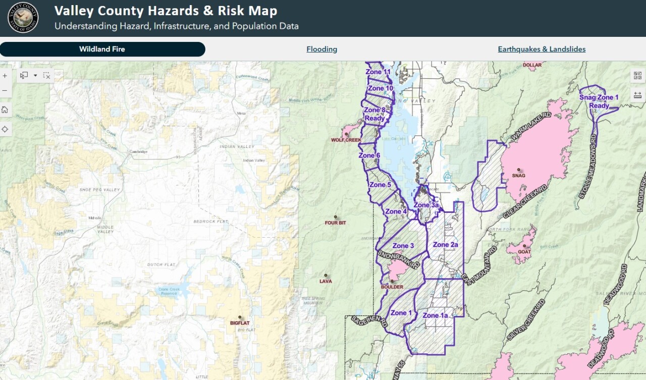
UPDATE: (Sept. 9, 2:45 p.m.): The Valley County Sheriff's Office is ordering a "GO NOW" evacuation for residents in Zones 4, 5 and 6. An interactive map to see where your zone is can be found online.
Related: Lava Fire grows significantly with weekend winds, evacuations expanded
Those in "GO NOW" zones need to leave immediately. Roadblocks on West Mountain Rd will be moved north, near Hurd Creek. No access will be allowed in the area once you leave.
Zones 7, 8 and 9 are now under "SET" evacuation notices. Those under this notice should be ready to leave at a moments notice. Sign up for CodeRed Alerts here.
Update (as of Sept. 8): The Valley County Sheriff's Office was just advised by West Mountain Fires that a GO evacuation order be placed for residents in the path of the Boulder Fire to include Zones 4 and 5.
Deputies will be going into the area and notifying residents. Expect roadblocks will be placed on West Mountain and Cabartonat some point.
"READY" evacuation notices are in place for Zones 6 - 11. That includes all homes on West Mountain, from Wapiti Dr. north to West RoseBerry Rd. Residents trying to access their homes will need to travel from Donnelly south. There are no roadblocks in zones 6 - 11 at this time.
Update: As of September 6th 2024
West Mountain Fires are burning for a combined 45,000 acres across the Cascade area. The most prominent fire burning the most acres is the Snag fire at 32,478. Boulder Fire is the most contained with over 24%.
Boulder: "Set" and "Ready" are in effect
During last night the fire crews were monitoring fire lines with engines looking for hot spots to work on. Today, the firefighters will be helping the containment lines that have been identified for major hot spots.
Dollar:
The fire growth for the Dollar fire is still at minimal growth. The north is seeing some creeping behavior near rocky terrain. The fire is being monitored with crews needing to remove unneeded equipment.
Snag:
Warm Lake road remains open from 9 a.m. to 6 p.m with just one lane of traffic. With crews working to improve the edge of Warm Lake Rd, 409 Clear Creek Rd and the West Flank, they hope that people traveling through watch their speed and look for emergency vehicles.
Goat:
The growth has minimize for this fire since yesterday. Crews are working on containment on the north end and continuing to secure that area. The focus today is to monitor the growth from north and south with the trail 099 as a tool of utilization for working the blaze.
West Mountain Fires have been burning near and around Cascade Idaho due to lightining strikes. The fires burning are the, Boulder, Snag, Dollar, and Goat. The Boulder Fire is 6 miles SW of Cascade, Snag Fire is 11 miles E of Cascade, Dollar Fire 18 miles NE of Cascade, and Goat Fire is 11 miles SE of Cascade.
With clearing skies and higher temperatures coming in, fire activity will increase. The winds will be shifting southwest with some potential for higher fire activity.
Historic averages for fire-season indicate that mid-October would be close to containment for these West Mountain Fires. With help from the Army of the 14th Brigade Engineer Battalion suppressing some of the fire activity they hope to achieve that mid-October goal.
Boulder Fire: (3,957 acres - 24% containment)
Firefighters and army crews were working the fire in the Olson Creek and Brush Creek drainage. They were creating a dozer line around the northern end of the fire. They had some support from a Type 1 helicopter. The main focus is to make sure structures within the area are being safe and not getting in contact with the fire.
Dollar Fire: (4,170 acres - 8% containment)
The fire growth was minimal, with the western edge of the fire being confined. The northern edge is being monitored with minimal speed of winds helping the fire grow.
Snag Fire: (32,478 acres - 13% containment)
The growth has moved slowly to the eastern side within a previously burned area. A team of engines, crews, and personnel continue to assist on the structure paths of the fires, to make sure they are safe. Fire crews and army crews continue to also secure the southern edge of Fore Road 409 from the fire, with hoses and pumps.
Goat Fire: (3,952 acres - 8% containment)
Fire grew to the north and south with crossing south of the Middle Fork Payette River drainage. Forest Service Trail 099 is becoming a holding feature to help assess the needs of values at risk to be protected.
Both Boise National Forest and Payette National Forest has forest closures due to the West Mountain Fires
Boise National Forest
- Dollar/Oro Area, Trail, Road Closures
- Anderson-Bulldog-Nellie Fire Area, Road, and Trail Closure
- Boulder Fire Area, Trail, and Road Closure
- Wolf Creek Burned Area, Trail, and Road Closure
Payette National Forest
- Wolf Creek Burned Area Road and Trail Closure
- Dollar Fire Area and Trail Closure
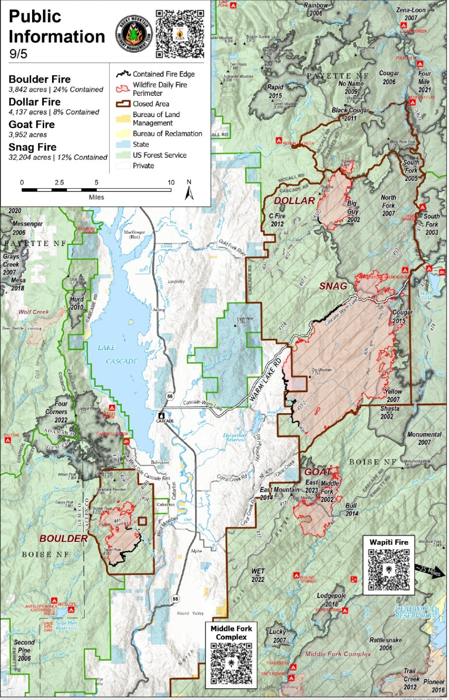
Warm Lake Highway is the only road closure due to the West Mountain Fires, with only homeowners and contractors being let in.