UPDATE: As of Saturday, Aug. 3
The RM CIMT Team Three will hand over fire management to a local Type 4 incident commander tonight at 6 p.m. Four engines, a water tender, and a fireline medic will stay to help with mop-up and patrol. The Temporary Flight Restriction over the Gwen Fire was lifted on August 2 at noon. This means non-mission aircraft, including drones, can now fly over the area. Aviation resources can operate without interference.
Expect delays on Highway 3 as the power company works to replace poles and repair lines to restore power to affected communities. Be careful when traveling through burned areas, as rain and wind may cause rocks and debris to fall on roads. You might see isolated smoke in some areas as fuels continue to smolder over the next few weeks.
Dry weather and high temperatures have sped up the burning process, aiding in the fire's quick containment. Stay extremely cautious in burned areas due to hazards like smoldering stumps, falling trees, and loose debris. Burned structures may also release toxic chemicals.
All roads and highways are currently open to the public
UPDATE (August 2, 9:00 am): The 28,410-acre Gwen fire is now 85% contained and fire crews are working to secure the perimeter of the fire in preparation to transfer command of the wildfire to a local Type 4 incident command on August 3.
An extreme heat warning is in effect for the area near the flames, firefighters could experience temperatures of up to 112 degrees.
UPDATE (Thursday, August 1, 11:00 am): The Gwen fire remains at 28,805 acres as the 307 assigned fire personnel have increased the containment of the flames to 65%.
Crews are working to remove hazards near the perimeter of the wildfire in hopes of continuing to stop fire growth as warmer temperatures and winds are on their way to the area.
All roads and highways are open to the public at this time, but remember to use extreme caution when traveling around the fire area.
UPDATE (Tuesday, July 30, 8:10 p.m.): All areas around the Gwen Fire have been changed to a Level 1 (Ready) evacuation level. Current evacuation levels can be found here.
Firefighters were able to capitalize on Monday night’s precipitation and made good progress across the fire, which is now 34% contained.
There will be a community meeting about the Gwen Fire at the Deary Rural Fire District at 6 p.m. on Wednesday, July 31. People can join in-person or join virtually on the Idaho Department of Land's Facebook livestream.

UPDATE (Tuesday, July 30, 9:40 a.m.): Firefighting efforts have continues on the 28,805-acre Gwen Fire, which is now 10% contained.
The containment area is located along the fire's edge, south of the Arrow Bridge through the area east of the intersection between N Tom Beall and Middle Tom Meall Roads.
Evacuation alerts are still in place for Latah and Nez Perce Counties, the latest updates on those evacuation levels can be found on the Latah County Facebook Page and the Nez Perce County Facebook Page.

Fire crews will be working to expand the containment area today, and early morning rain in the area has helped reduce fire risk as they continue fighting the fire.
UPDATE (Monday, July 29, 9:27 am): The lightning-caused Gwen Fire has grown to cover 28,805 acres as fire crews continue to work on suppression efforts. Containment is still at 0%.
The dozer line on the northwestern portion of the flames was completed yesterday, now crews are working on a fireline to halt the spread of the fire.
A community meeting is scheduled for 6pm at Lapwai Elementary School. You can join the meeting virtually on the Idaho Department of Lands Facebook Page.
Evacuation alerts are still in place for Latah and Nez Perce Counties, the latest updates on those evacuation levels can be found on the Latah County Facebook Page and the Nez Perce County Facebook Page.

UPDATE: As of Sunday, July 28
The Gwen Fire currently spans roughy 27,700 acres in northern Idaho, with containment still at 0%.
The Idaho Panhandle Hotshots are working in conjunction with heavy equipment to construct direct and indirect firelines to keep the fire east of Spalding, and Catholic Creek, and south of the communities of Julietta and Kendrick, and west of the communities of Amos Bench and Bedrock Canyon.
Varying evacuation levels are in place in Latah County. Go to the Latah County Sheriff's Office Facebook for latest evac levels.
UPDATE: As of July 26th 2024
Size: 20,000 acres
Containment: 0%
Number of Evacuees: Approximately 300
Road Closures: US Highway 12 is closed between Spalding and Peck. State Highway 3 is closed between Arrow Bridge and Kendrick. Gifford/Reubens Highway is also closed.
Firefighter crews and bulldozers are making good progress creating containment lines near the fire edge. Aircraft support has been effective in aiding ground crews and advancing containment efforts. However, wind remains a factor in how the fire spreads.
Several fires spread northeast of Lewiston, Idaho, following lightning on Wednesday, July 24. The Gwen Fire and River Fire are now being managed together as the Gwen Fire. The Rocky Mountain Complex Incident Management Team 3 will be briefed on Saturday evening to enhance firefighting efforts.
UPDATE(July 26, 12:45 pm): The Federal Emergency Management Agency (FEMA) has authorized the use of federal funds to fight the Gwen Fire burning in the Nez Perce Reservation and in Nez Perce and Latah counties, Idaho.
When Idaho officials made the request for federal funds, the wildfire threatened homes in and around the communities of Juliaetta, Myrtle, Arrow Junction, Lenore, and the city of Lapwai. The fire also threatened private and nonprofit public utilities and critical community infrastructure such as roads, bridges, public businesses and recreational areas.
This authorization makes FEMA funding available to pay 75% of eligible firefighting costs under an approved grant for fighting and controlling designated fires.
Another $985,111 will be available to Idaho through the Hazard Mitigation Grant Program for the mitigation of future wildfires and related hazards, such as flood after fire or erosion.
UPDATE(July 25, 9:44 pm): The Gwen and River fires are being measured at 2,000 acres each, prompting closures and evacuations.
The Idaho Transportation Department is alerting drivers in the area to a major closure on SH-3 from SH-3 Southbound to McGary Grade. All lanes are closed.
In the same area, another major closure on US-12 is stopping traffic in both directions from US-95 to Big Canyon Rd.
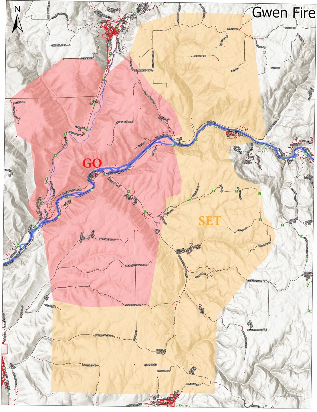
The Latah County Sheriff's Office has released a map with updated evacuation levels (below) for the surrounding cities.

Residents of Nez Perce County can find the evacuation information for the county on their interactive evacuation map page.
Evacuation relief sites for those effected by Latah County Fires are at the Latah County Fair and Events Center. The barns are open for stalling animals, and the East Field (Carnival Area) is open for RV, Trailers, and Vehicles.
Other Evacuation relief centers are the Troy High School and the LDS Church off of Big Meadow Rd.
July 24th the Gwen fire was reported south of Juliaetta Idaho. The report came in just 30 miles outside of Lewiston near State Highway 3 in Latah County.
The Gwen fire has reached just over 2,000 acres near the Clearwater River.
The agencies included in helping subdue the fire are, The Nez Perce Tribe, Idaho Department of Lands, area rural fire departments, and local landowners. Evacuations are in place with road closures, with some structure loss. The resources on hand are some fire crews, engines, dozers, water scoopers, air tankers, and helicopters.